
Editor’s note: This is one of the final parts of our Transpo(nation) series, in which Andrew Carpenter bicycled across the U.S. – from San Francisco back to Washington, D.C. – to report on transportation options.
A series about transportation across the United States would be remiss to gloss over the country’s highway system. Rather than connecting places, highways affected my trip mostly in how I could not use them.
Riding along even state routes proved dangerous: restricted access roads near Maryland’s Chesapeake Bay Bridge forced me around – instead of over – some boundaries, and massive structures divided neighborhoods in the cities I explored, like the I-43 and I-794 interchange in Milwaukee, Wisconsin, which cleaves through Marquette University’s campus and walls it off to the south. From a cyclist’s perspective, the limits that car-centric infrastructure places on mobility are obvious.
🚶 @webnextnova/@Gannett is less than ¾ mile from McLean Metro, but Google shows a 4.2-mile, 85-min walk to get there pic.twitter.com/8U2uOB3CtJ
— Michæl Schade 🚲💨 (@mvs202) September 13, 2016
This June marked the 60th anniversary of President Dwight D. Eisenhower signing the Federal-Aid Highway Act of 1956, which established the interstate system as we know it now.
Much like the railroad expansion of the 1800s played a huge role in national growth and westward expansion, the interstate system played a pivotal role in development and social evolution through the second half of the 20th century, though with a highly mixed legacy. As many segments of the Interstate system near the end of their useful life, more cities are questioning their value and are considering other options as they move past a car-dominated transportation system.
(Mostly) unintended consequences
While the interstate system allowed for the creation of affluent suburban communities by establishing car access to downtowns, it had the opposite effect within cities by fragmenting neighborhoods.
It’s widely told that when President Eisenhower signed the Federal-Aid Highway Act, he hadn’t intended for interstates to develop the way they did. Instead, the supposed goal was to establish interurban freeways that connected cities and ended with a distinct, separate road network upon reaching these dense areas. It would have created two complementary systems that provided fast, cheap transport through spacious rural areas and funneled vehicles into densely populated areas without tearing apart the urban fabric by prioritizing traffic flow.
However, the aggregated effects of lobbying, concessions to urban elected officials to justify funding, and less-than-subtle racial discrimination, pulled the country’s interstates into auto-centrism. Transportation planners came to neglect transit and walking, leaving travelers in many areas without options and disrupting urban cores in a way that negatively affected poor, minority communities at disproportionately high rates.
In the end, focusing so heavily on developing car infrastructure without any alternative modes backfired, creating communities that are entirely dependent on personal vehicles. Thanks to the phenomenon of induced demand, expanding roads doesn’t solve the mobility issues that highways are supposed to address, and they sink into a spiraling strain on states, overspending to maintain or expand them, further creating car demand and crowding out more efficient modes physically and financially.
New approaches
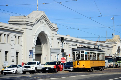
Transportation infrastructure, in any form, is expensive to build and to keep up. Six decades after President Eisenhower signed the interstate system into law, it is getting old, deteriorating faster than it can be maintained. In many places, sustaining interstates is becoming more expensive than the value they supposedly add. As a result, cities from San Francisco to Rochester, New York and Providence, Rhode Island have been rethinking the presence of highways within their cores.
Though voters rejected tearing down San Francisco’s Embarcadero Freeway in 1986, the freeway had to come down after the Loma Prieta earthquake, and has since become a multimodal waterfront area (above). Rochester has begun filling in a portion of I-490 with plans to reconnect the neighborhoods that they cut off. The city of Providence and a wide set of stakeholders are currently fighting the Rhode Island Department of Transportation’s plan to scrap plans for an urban boulevard and instead reconstruct a highway interchange, indicating how entrenched car-centric planning remains, despite its known negative impact on cities.
And even in D.C., the ongoing Capitol Crossing project is reconnecting part of downtown with a seven-acre cap over I-395. The development looks to bridge the downtown region with the Union Station and NoMa areas in the city’s Northeast quadrant, which can feel physically and psychologically divided by arterial roads like the interstate.
Nationally, Transportation Secretary Anthony Foxx is looking to take advantage of the opportunity that the aging infrastructure and changing mentalities offer at the city level, and shows promise of changing the national paradigm for how we approach transportation planning. Speaking on NPR in May, Secretary Foxx touched on the ill effects of urban highways, the idea that planners must be conscious of how they replace aging infrastructure, and the necessity of rebuilding in a more equitable, multimodal way.
Building on that, the department unveiled a growing focus on changing transportation to be more inclusive, efficient, and responsible. This summer, USDOT launched the Every Place Counts Design Challenge, seeking to “identify innovative community design solutions that bridge the infrastructure divide and reconnect people to opportunity.”
As interstate infrastructure ages, it provides an opportunity for us to focus on new modes that improve mobility and accessibility, being careful to ensure the new expansion of American transportation is more equitable and sustainable than in the past. Applying this 60-year lesson into how the U.S. prioritizes transportation projects should ultimately reconnect neighborhoods and make possible more non-driving transportation options.
Photos: Top, Interstate 794 cuts off Milwaukee’s Lake Michigan shore, to the left of the photo (Jaremey Jannene, Flickr, Creative Commons). Middle, San Francisco’s post-highway Embarcadero (M.V. Jantzen, Flickr, with permission).